Reference Map
Thematic Maps: The LA Station Fire and Significant Ecological Areas
  |
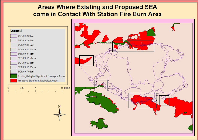
| This map shows how the fire spread outward toward Significant Ecological Areas. |


Report
The Station Fire that occurred in the Los Angeles National Forest in August and September of 2009 was one of the most devastating fires that burned through California's wildlands that year.The fire started out relatively contained to one area. The burn area is undeveloped, but not far from populated Los Angeles suburbs such as Glendale, Montrose, and La Canada Flintridge. The fire perimeters on the map show that the fire spread hourly, often expanding many square miles outward in a brief time. The time lapse between the first and second burn area perimeter is only about twelve hours, so it is apparent that the fire was moving rapidly. The most notable expansion of the fire took place on August 30. The burn area doubles in size expanding in a north east direction. The fire expanded quickly but remained in the relatively vast space between Palmdale, La Canada Flintridge, and Agua Dulce. The lack of development in this region is likely due the higher slope that is visible compared to other regions in Los Angeles County.
The theme of the map is the spatial relationship of Significant Ecological Areas(SEA) in Los Angeles County to the fires and how they were affected. Significant Ecological Areas are regions within Los Angeles that have been surveyed and deemed ecologically important. These sights are not established preserves, but land and water sources that support
valuable habitat.The program is a part of the Los Angeles County General Plan Conservation/ Open Space Development through the county Department of Regional Planning. It began in the 1970s but new research is mapped consistently, providing people with a visual display or important habitats in the county. The SEA have the goal of protecting
fragile environments and the habitat of the species, sometimes
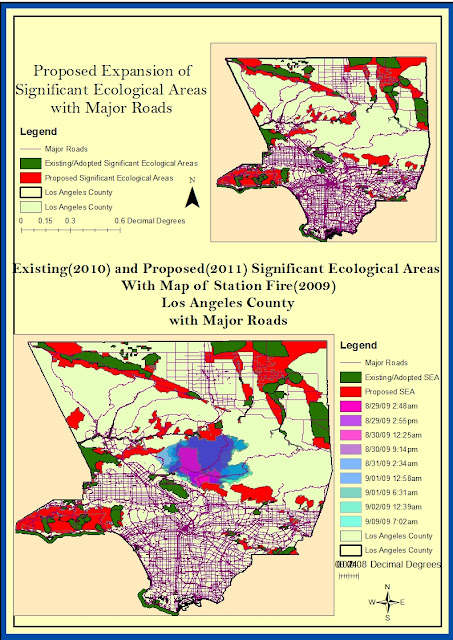
endangered, within them.The maps in this project show where existing ecological sites were established as of 2010, one year after the Station Fire, as well as the locations of proposed SEAs made in 2011. This thematic map allows the reader to see that the fire was fought in a way that protected the county's SEA. This is apparent in the large SEA located southwest of most of the burn area. It is likely that this was due to concern over human populations and structures such as homes more than the Significant Ecological Areas. The few areas where the fire extended into the existing and proposed Significant Ecological Areas is also mapped. Most of the the Significant Ecological Areas in close proximity to the fire escaped without burning. Given the fire spread pattern, any more expansion in the north direction could have damages an SEA or significant ecological site(lacounty.gov).
My hypothesis is that fire is not the main threat to ecosystems and that the Station Fire was not the largest threat to existing or proposed Significant Ecological Areas in Los Angeles County. The map of existing Significant Ecological Areas was created in the year following the Station Fire. The closest SEA to the fire lies on the outermost edges of the burn area, with none in the middle. The Department of Regional Planning has not deemed the majority of the burn area as significant, which is interesting because it is a large area of open land, free of major development. One reason for this is that fire is a natural occurrence in this type of Western United States forest, chaparral, and shrub ecosystem(Noss).The people deciding the location of the SEA may not see these areas as needing to be protected because they have just undergone a natural process. Another idea for the lack of spatial relationship between the Station Fire and SEA is that fire eliminated the biodiversity necessary to be a Significant Ecological Area in the burn area. Sometimes after fires wildlands have trouble returning to their natural state because of changes in conditions: "ash and sediment runoff into waterways, predation in the open habitats, invasive species including weeds and pests, browsing and grazing of regenerating vegetation,inappropriate fire regimes" (www.dse.vic.gov.au). These factors may cause the region to no longer be significant to the county, but even harmful to nearby wildlands. A very practical analysis would be that the fire was contained before reaching major ecological areas. With time conditions became less hot and windy, and more funds came in to help fight the fire(Garrison, Zavis, Mozingo).
Proposed Significant Ecological Areas appear to be located in areas where development will take place. This is visible in the included map showing major roads in Los Angeles County. Many of the proposed and existing SEA are closer to more metropolitan areas, but are also almost non existent because of these roads. This leads to another hypothesis that development is more detrimental to Significant Ecological Areas than wildfires. There is a lack of SEA in the southern portion of Los Angeles County. However the maps show how many major roads and highways are located in this region. Roads and highways are indicators of development and high population, but they have consequences such as erosion, runoff, and isolating fauna(enviroment.fhwa..dot.gov). Due to these regions already being urbanized, the potential Significant Ecological Areas in this region of the county are already gone. The lack of any SEA being located where the majority of roads are shows how development hurts ecological areas.
Based of the maps I created I conclude that areas considered Significant Ecological Areas will continue to expand. In just one year the area between the existing and proposed SEA grew dramatically. The Proposed SEA map already expands more into the burn area of the Station Fire. With wild fires being an issue that has only been getting worse(Keeley, Forthingham, Morais), and SEA expanding, the two are likely to overlap more in the near future. In urban cities like Los Angeles, growing populations mean that development expands outward. This means that more homes, roads, and businesses will be constructed on California's wildlands. This is dangerous because these areas are prone to small natural fires(Noss). It also eliminates the homes of flora and fauna native to the region. These species are important to the ecological functions in the environment of Los Angeles County. The full consequences are unknown until too late, when the entire county is developed. It is very important to have an understanding of Significant Ecological Areas in any location. This becomes even more important in an area prone to fires. The fire did not spread far into the highly sloped area of the county, and none of the sloped area is included in the significant ecologic areas as well. The fact that the region surrounding the fire is hilly could have helped protect the SEA. It is less likely that the sloping region will be used for homes and structures over flatter areas. This could help the burn area from the Station Fire grow and help the species in this area recover from the fire. Another reason that the fire seemed to spread in the opposite direction of development is because more was done to ensure the safety of these structures. The priority of the fire department is first to protect people, but then to protect structures such as homes and schools. Because the majority of the counties population is located south of the fire, this region was held while the fire expanded outward. It is obvious that Significant Ecological Areas will never compete with human lives and expensive structures in need for protection. However, it is important that people do begin to understand just how important they are for environmental processes.
The thematic maps show that the number of significant ecological sights will be growing. This thematic map is important in understanding how to fight future fires. These areas need to avoid the intensity of fires like the Station Fire, so the map helps the state understand where to take precautions against future burning. Fires are not the only threat to these lands. Developed area, expressed by highways on these maps, are relatively absent of SEA except for area trying to survive around the edges. Geographic information systems and programs like ArcGIS are important in improving these environmental issues. Mapping the area shows the entire extent of the fire on individual days. It helps understand what makes the fire grow, as well as teach lessons on how to better contain it in the future. With the SEA, mapping is important in monitoring where fragile environments are. These maps help urban planners decide how to urbanize areas with convenience to people while trying to minimize damage to ecosystems. The areas deemed Significant Ecological Areas contain resources or habitats that are crucial to the entire ecosystem. In a place that is extremely developed and always evolving like Los Angeles, it is even more important to map, monitor, and preserve these areas.
Works Cited
Boxall, Bettina, and Julie Cart.
"As Wildfires Get Wilder, the Costs of Fighting Them Are Untamed." Los
Angeles Times. Los Angeles Times, 27 July 2008. Web. 6 June 2012.
Franklin, Jerry F., William L. Baker,
Tania Shoennagel, and Peter M. Moyle. "Ecology and Management of Fire
Prone Forests of the Western United States." Ed. Reed F. Noss. Society
for Conservation Biology Scientific Panel on Fire in Western U.S. Forests
(2006): n. pag. Web.
Garrison, Jessica, Alexandra Zavis,
and Joe Mozingo. "Station Fire Claims 18 Homes and Two Firefighters."
Los Angeles Times - California, National and World News - Latimes.com.
N.p., 31 Aug. 2009. Web.
"Investigation under Way into
Cause of Station Fire." CNN. N.p., 01 Sept. 2009. Web. 12 June
2012.
<http://articles.cnn.com/2009-09-01/us/california.wildfires_1_angeles-national-forest-fire-officials-fire-chief-mike-dietrich?_s=PM:US>.
Keeley, Jon, C.J. Fotheringham, and
Marco Morais. "Reexamining Fire Suppression Impacts on Brushland Fire
Regimes." Science Vol. 284.No. 5421 (1999): 1829-832. Print.
Levin, Myron. "Conference to
Discuss Ecological Areas." Los Angeles Times. Los Angeles Times, 06
Dec. 1990. Web. 7 June 2012.
Longcore, Travis. "Ecological
Effects of Fuel Modification on Arthropods and Other Wildlife in an Urbanizing
Wildland." (2003): 111-17. Web. 7 June 2012.
"Los Angeles County Department
of Regional Planning." SEA Program. N.p., n.d. Web. 11 June 2012.
Meyn, Andrea, Peter S. White,
Constanze Buhk, and Anke Jentsch. "Environmental Drivers of Large,
Infrequent Wildfires: The Emerging Conceptual Model." (2007): n. pag.
SagePub. Web. 12 June 2012.
"Natural Environment
Recovery." Natural Environment Recovery. N.p., n.d. Web. 10 June
2012.
"Wildlife and Habitat." Environmental
Review Toolkit. N.p., n.d. Web. 125 June 2012.


No comments:
Post a Comment